A Century Of Changes In The Scottish Landscape
Research by a team at the Macaulay Land Use Research Institute in Aberdeen aims to reveal the types and extent of changes in the Scottish landscape over the past century through a systematic comparison of historical and contemporary photographs. The team is also interested in discovering how people perceive these changes. Do most people focus on changes in cultural features like buildings or on semi-natural features like woodlands, and how do they describe the changes?
There is a wealth of historical landscape photography available through the archives held in several Scottish Universities, for example the Adam and Valentine collections at the University of St Andrews and the George Washington Wilson collection at the University of Aberdeen.
Careful re-photographing the scenes of old photographs with support of modern image processing technologies allow us to digitally match these historical images with contemporary images taken from approximately the same viewpoints. These can then be superimposed. This enables us to identify where changes have occurred and also to calculate how extensive these changes have been. By showing these historical and contemporary images to a wide range of people and asking them to ‘spot the differences’, the team will be able to better understand what people perceive as significant differences and test various ideas about what makes some changes more or less acceptable.
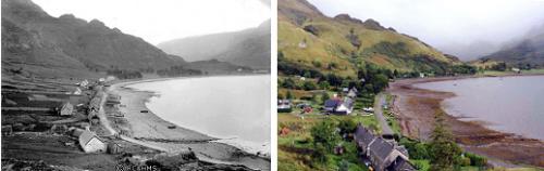
Staff from the Macaulay Land Use Research Institute attended the Royal Highland Show, Ingliston, Edinburgh from 25th-28th June 2009 to encourage visitors to play an active part in the research project by doing a ‘comparison' exercise on two views of the small west coast township of Arnisdale taken in 1896 and 2006.
(images copyright RCAHMS and Dr Rick Rohde).
Published on 07 July 2009 in Sustainability and Communities , Climate, water and energy
Topics
- Climate, water and energy
- Ecosystems and biodiversity
- Food, health and wellbeing
- Sustainability and Communities