Climate Change And Land Capability For Agriculture (LCA)
Published on 16 April 2009 in Climate, water and energy
Introduction
The Macaulay Land Capability for Agriculture (LCA) system is widely used by planners, land managers and increasingly by policy makers in Scotland. The LCA system is based upon the original guidelines and maps published in the early 1980s. We are currently in the process of updating and revising the original information using new data and methods. Its utility means that the new information will have significant implications for land use policy, planning and management. The LCA system identifies the flexibility of the land for different agricultural uses or management practises, and is based upon the physical constraints on land use: soils, climate, topography and vegetation. The higher classes in the system (1, 2 & 3.1) are the most flexible and together are defined as ‘prime land’ with a presumption against further built development (although this was relaxed in 2001 after public consultation). With climate being one of the key components of the LCA system, a change in climate therefore has significant implications for how we plan and manage land, both now and in the future (depending on the relevant planning horizons).
Key Points
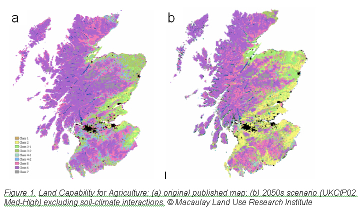
As a pilot project at the Macaulay Land Use Research Institute, we have updated the original climate data used in the LCA mapping with present-day data and used these to evaluate the impact of climate change in recent decades. We have also explored future climate change through the national (UK Climate Impacts Programme - UKCIP) climate change scenarios. The results showed that there had been a subtle but significant change in climate since the original LCA was published, producing a small increase in ‘prime land’ in Eastern Scotland. For the future, much larger changes are projected under the climate change scenarios (Figure 1) implying both a large increase in ‘prime land’ and also that some of the currently ‘unimproved’ (class 6) land in the uplands could potentially provide improved grazing as well as rough grazing. We presented these interim results at a Stakeholder Workshop in 2008 and published a Briefing Report on the main issues including the workshop conclusions.
Research Undertaken
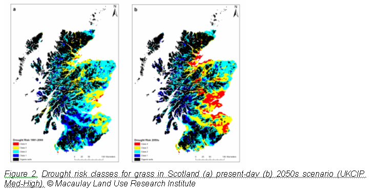
The original LCA was based on detailed field surveys and maps drafted manually.. The pilot project began work on developing a revised digital procedure using a Geographical Information System (GIS) approach, but with the aim of replicating the original as much as possible. This is now being followed by a more detailed assessment including not just climate, but also soil properties, soil-climate interactions, vegetation and topography. The research is following the original LCA guidelines but where necessary is updating them with new data and evaluating the original guidance against new knowledge. As an example, consider our work on drought risk which involves an assessment of soil moisture deficits and the water demand from different crops. A preliminary assessment (Figure 2) of this soil-climate interaction shows that it could become much more significant for some areas in the future, which will require a locally-based reappraisal of Figure 1b. We are also updating the climate change information based on the new UKCIP09 climate projections.
Policy Implications
Author
Iain Brown, Helaina Black, Willie Towers, Laura Poggio I.Brown@macaulay.ac.uk