Scotland's Water Resources: Impacts of Land Use and Climate Change
Published on 29 January 2013 in Climate, water and energy
Introduction
The Land Use Strategy for Scotland (LUSS) highlights the need for increased food security over the coming decades and also identifies forest expansion as a means to both capture CO2 and to provide a sustainable fuel source. As intensive food production and forestry are associated with higher rates of evapotranspiration than most other land uses, this is likely to result in a decrease in the amount of water reaching reservoirs, streams and groundwater bodies (hereafter referred to as “runoff”). Climate change is also likely to affect water resource availability by (a) changing the distribution and amount of water in the system and (b) changing the capability of the land to grow crops and therefore influencing land use.
Climate, land use and water availability are therefore closely linked, requiring an integrated approach to assess future strategies.
Key Points
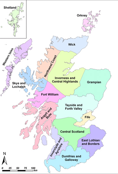 A national scale water balance model has been used to assess changes in runoff across Scotland under one scenario of land use change (compatible with the LUSS) and two simulations of climate change. The output has been summarised over Scottish Water’s 16 water resource “megazones” (Figure 1). Results indicate that:
- In many zones, decreases in annual runoff due to land use change are substantial (up to 100 mm per year). In places, the effect of land use change equals or exceeds that of climate change.
- In terms of annual water budgets, the climate simulations do not offer a coherent picture of future available water resources. The differences are especially marked in the east of the country.
- During the summer months, the climate simulations are more consistent. The combined influence of land use and climate change in this season is predicted to cause a decrease in runoff of up to 80 mm (Figure 2, bars D and E).
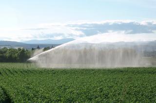
- Summer runoff is important for crop growth, so the modelled decreases would need to be offset by increased irrigation in agricultural areas. This would place additional pressure on the supply infrastructure, which does not currently have to meet this demand.
- Decreases in summer runoff may be offset by increases during other seasons. If this water can be effectively stored (in aquifers and reservoirs) Scotland’s overall water resources may not be adversely affected.
Figure 1: Scottish Water's 16 water resource "megazones"
Research Undertaken
A spatially distributed water balance model, incorporating datasets representing climate, soil properties, hydrology and land use, has been used to estimate long-term, average runoff for particular areas of interest.
The model uses two climate simulations broadly representing the range of uncertainty encapsulated by the Met Office’s 11 member Perturbed Physics Ensemble for the IPCC medium emissions scenario. It also incorporates a future land use scenario focusing primarily on the expansion of agriculture and forestry, as outlined by the LUSS. The Land Capability for Agriculture 2050 dataset (LCA2050) identifies areas of the country which may become suitable for agriculture in the future as a result of climate change. To guide the expansion of agriculture, we have therefore assumed that all prime land in LCA2050 is used for arable farming by the 2050s.
For forestry, we have combined information from the Woodland Expansion Advisory Group with the Land Capability for Forestry map to identify areas of possible woodland expansion. The Scottish Government has a stated aspiration for 25% total forest cover in Scotland, which we assume to be achieved by the 2050s. Areas of land not converted either to arable agriculture or to forestry are assumed to be used in the same way in the 2050s as they are on the Land Cover Map 2007, which is the most up to date national scale land use dataset for Scotland.
Figure 2 shows the simulated change in summer runoff (in mm) compared to the baseline for each of the 16 water resource megazones (Figure 1). The bars on each plot represent a different combination of future scenarios:
A – Land use change, but no climate change;
B – Climate simulation 1, but no land use change;
C – Climate simulation 2, but no land use change;
D – Climate simulation 1 with land use change;
E – Climate simulation 2 with land use change.
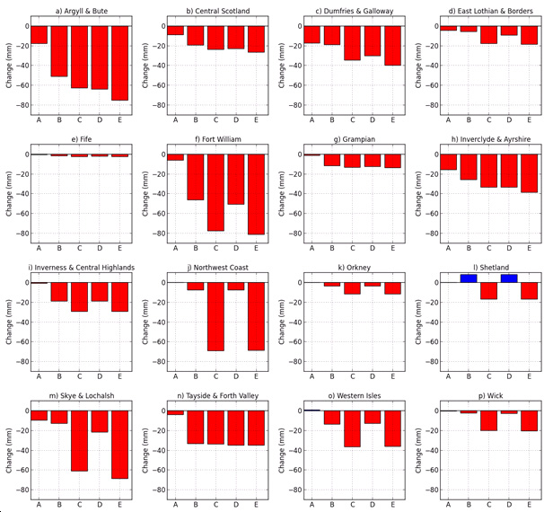
Figure 2: Simulated change in average summer runoff (in mm) for each megazone for the period from 2041 to 2070. Red refers to a decrease, while blue refers to an increase.
Policy Implications
It is important to understand that the decreases in runoff shown in Figure 2 do not necessarily equate to water shortages in the future: if aquifer and reservoir capacity are sufficient to store any increases in autumn and winter runoff, there may still be enough stored water available to meet summer demand. In this case, the main consequence of decreased summer runoff is likely to be an increase in irrigation demand during the growing season, which would place additional pressure upon the water supply network.
One of the key findings of this work is that the large scale land use changes associated with policy issues such as food and energy security may have a significant impact on the nation’s water balance: in some cases the effects of land use change may be comparable in size to those of climate change. In some areas, afforestation and agricultural expansion/intensification may be constrained by the availability of water resources and by the capacity of the supply network to meet increases in demand for this resource. This has consequences for the practical implementation of the Scottish Government’s Land Use Strategy.
Author
James Sample, James Hutton Institute james.sample@hutton.ac.uk